The availability and use of geographic information technologies and data for describing the patterns and processes operating on or near the Earth’s surface have grown substantially during the past fifty years. The number of geographic information systems software packages and algorithms has also grown quickly during this period, fueled by rapid advances in computing and the explosive growth in the availability of digital data describing specific phenomena. Geographic information scientists therefore increasingly find themselves choosing between multiple software suites and algorithms to execute specific analysis, modeling, and visualization tasks in environmental applications today. This is a major challenge because it is often difficult to assess the efficacy of the candidate software platforms and algorithms when used in specific applications and study areas, which often generate different results. The subtleties and issues that characterize the field of geomorphometry are used here to document the need for (1) theoretically based software and algorithms; (2) new methods for the collection of provenance information about the data and code along with application context knowledge; and (3) new protocols for distributing this information and knowledge along with the data and code. This article discusses the progress and enduring challenges connected with these outcomes.
More details can be seen in our paper at:
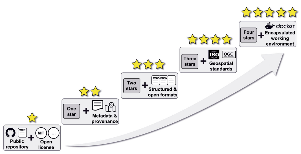
John P. Wilson, Kevin Butler, Song Gao, Yingjie Hu, Wenwen Li and Dawn J. Wright (2020): A five-star guide for achieving replicability and reproducibility when working with GIS software and algorithms. Annals of the American Association of Geographers, in press. [PDF]
This paper is one of the articles in a collection on R&R in GIScience. You can find the full collection here: https://sgsup.asu.edu/forum-articles-reproducibility-and-replicability-published-annals-american-association-geographers