Funded Projects
GeoAI for Studying Disaster Resilience and Human Behaviors
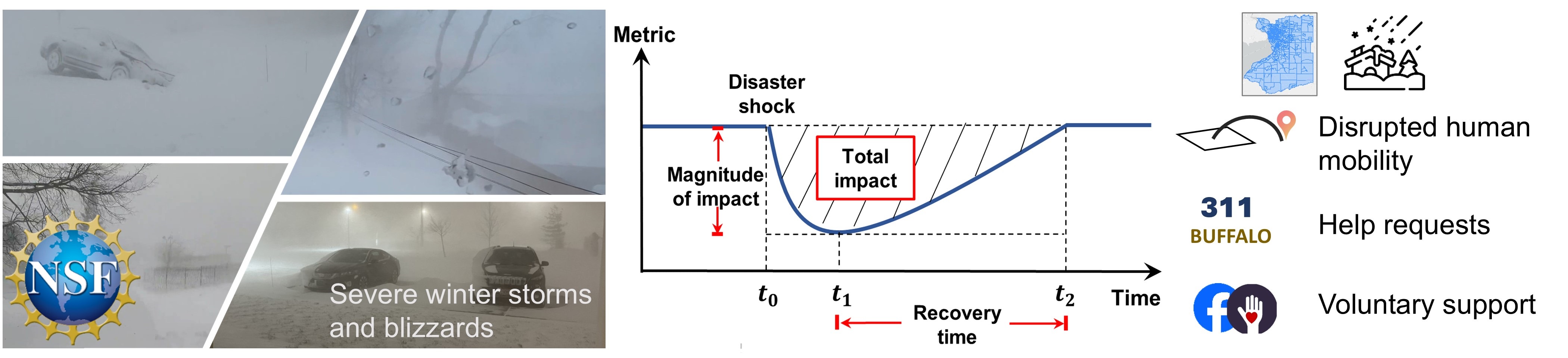 This project examines three aspects of the human responses to natural disasters. First, anonymized mobile phone location data and GeoAI methods will be used to investigate spatial variation in the disrupted patterns of mobility. Second, we investigate spatial disparities in the extent to which residents request assistance from municipal authorities. Third, we study the geography of help-seeking behavior among social media users and the roles of digital platforms in facilitating voluntary support. The project will also examine factors associated with the variation of human behaviors and community resilience.
NSF award page: https://www.nsf.gov/awardsearch/showAward?AWD_ID=2416886
GeoAI for Anomaly Detection During Natural Disasters
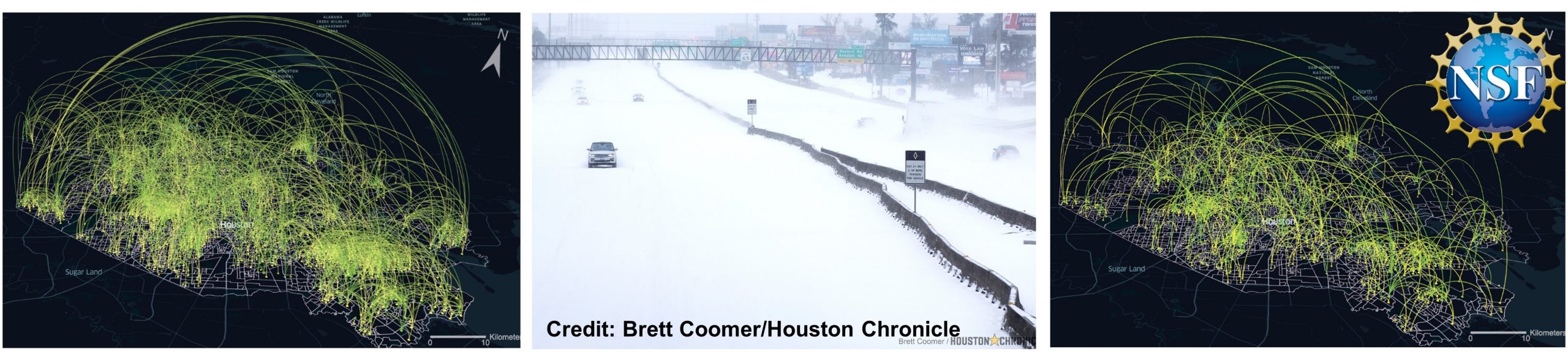 Human mobility data from anonymized mobile phone devices are becoming increasingly available, enabling the detection of anomalies from human movements. Different categories of places (e.g., grocery stores and schools) can be linked to human movements, and anomalies that are evident in one category may be obscure in another. This project will furnish new mathematical models, theories, and algorithms for encoding human movements into spatial-temporal multilayer networks and for detecting movement-pattern anomalies under events such as natural disasters.
NSF award page: https://www.nsf.gov/awardsearch/showAward?AWD_ID=2401276
GeoAI for Disaster-related Location Understanding and Extraction
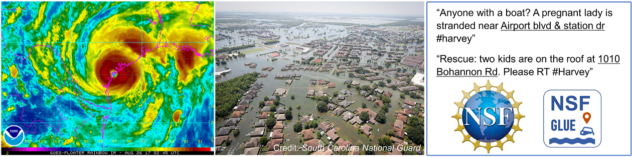 Social media platforms, such as Twitter, are increasingly being used by people impacted by natural disasters. Descriptions about the locations of victims and accidents are often contained in help-seeking messages posted on these platforms. However, a limited understanding exists of how locations are described on social media during natural disasters, which hinders their automatic extraction via computational tools. This project aims to fill these knowledge gaps.
NSF award page: https://www.nsf.gov/awardsearch/showAward?AWD_ID=2117771
GeoAI for Ecosystem Monitoring and Management
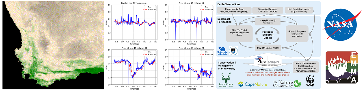 This project aims to integrate big geospatial data (e.g., remote sensing images, in-situ observations, and citizen science data) and artificial intelligence models to provide near-term ecological forecasting and change detection in a global biodiversity hotspot: the fynbos of the Cape Floristic Region (CFR) of South Africa. The developed models and systems will provide critical information to help decision makers better manage the biodiversity, water, fire, and carbon stocks in the study region.
NASA award page: https://cce.nasa.gov/biodiversity/_biomap/projmap.html
Exploratory Projects
GIS-based Data Augmentation for Deep Learning
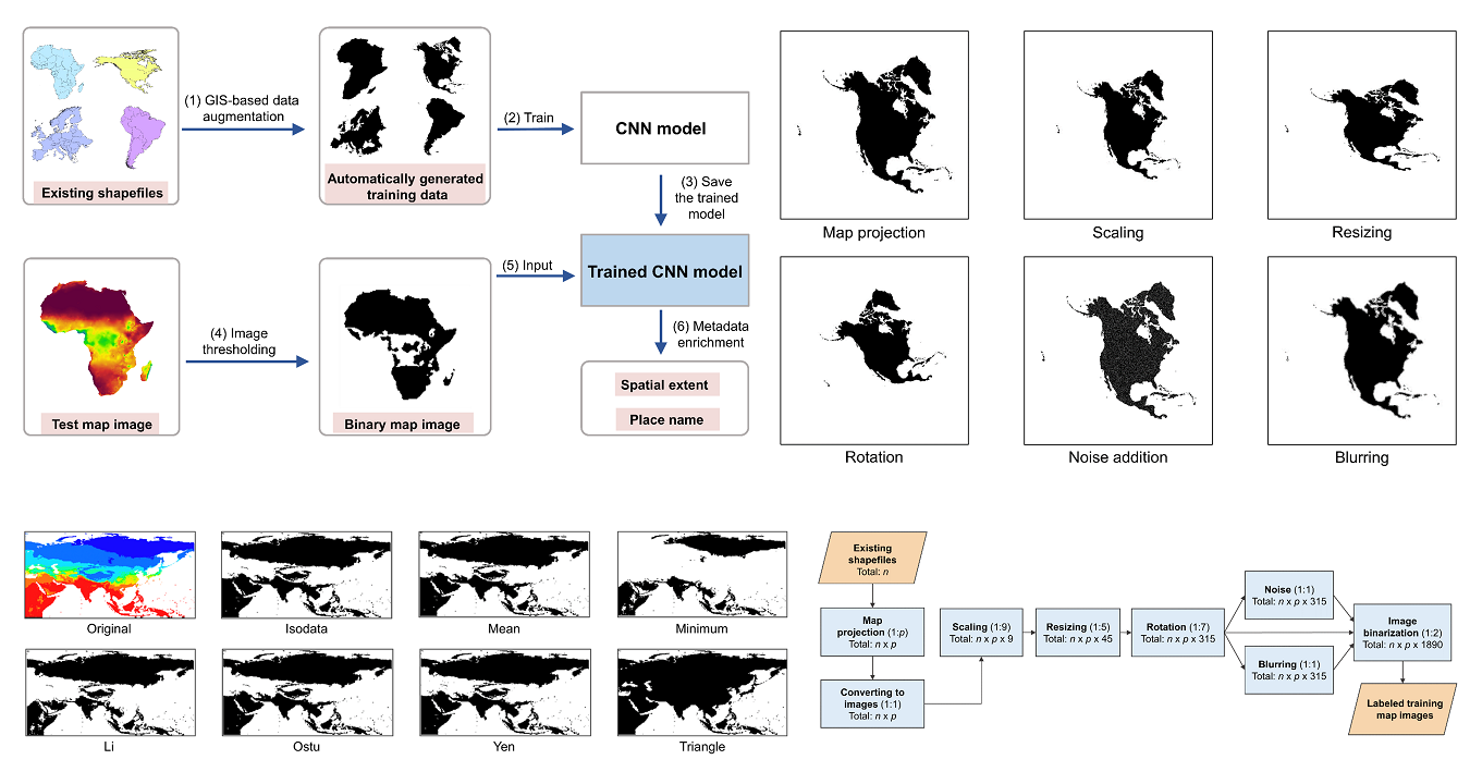 One major challenge of using deep learning models is that they often require large amounts of training data that have to be manually labeled. We proposed a deep learning approach with GIS-based data augmentation that can automatically generate labeled training map images from shapefiles using GIS operations. We utilize such an approach to enrich the metadata of map images by adding spatial extents and place names extracted from map images.
Paper: https://www.tandfonline.com/doi/full/10.1080/13658816.2021.1968407
Code and Data: https://github.com/geoai-lab/MapMetadataEnrichment
Historical Maps and Geographic Knowledge Graphs
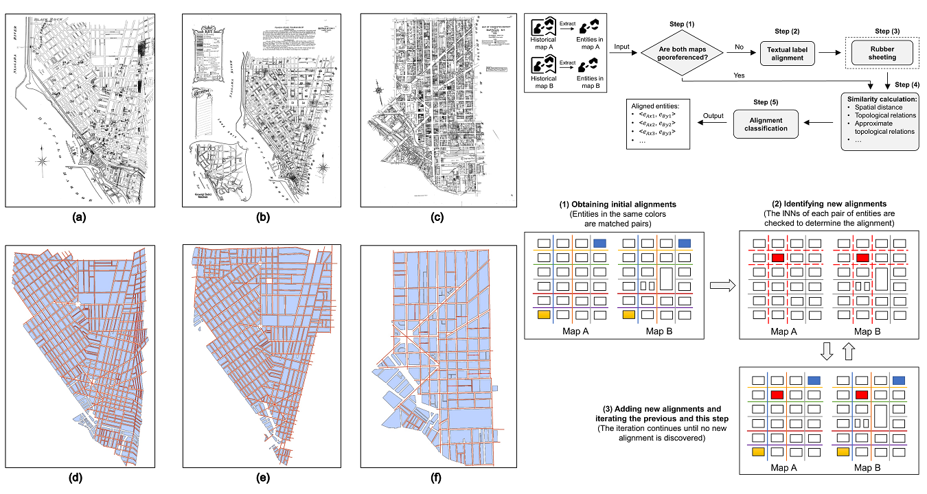 Historical maps contain rich geographic information about the past of a region. This project proposes a general workflow for completing one important step of building a geographic knowledge graph (GKG) from historical maps, namely aligning the same geographic entities from different maps. We experiment with different methods for implementation, and systematically evaluate their performances using two datasets of historical maps.
Paper: https://www.tandfonline.com/doi/full/10.1080/13658816.2020.1845702
Code and Data: https://github.com/geoai-lab/MapKnowledgeBase
NeuroTPR: a Neuro-net ToPonym Recognition model
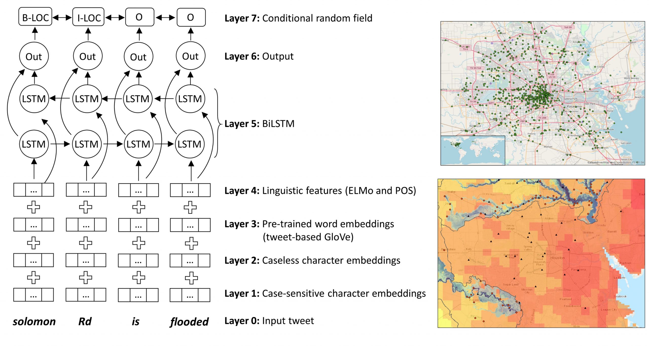 This project develops NeuroTPR, a Neuro-net ToPonym Recognition model designed for extracting locations from social media messages. Our approach extends a general bidirectional long short-term memory (BiLSTM) model with a number of features designed to handle the language irregularity in social media messages. This model was applied to a dataset of tweets from 2017 Hurricane Harvey.
Paper: https://onlinelibrary.wiley.com/doi/abs/10.1111/tgis.12627
Code and Data: https://github.com/geoai-lab/NeuroTPR
Extensible and Unified Platform for Evaluating Geoparsers
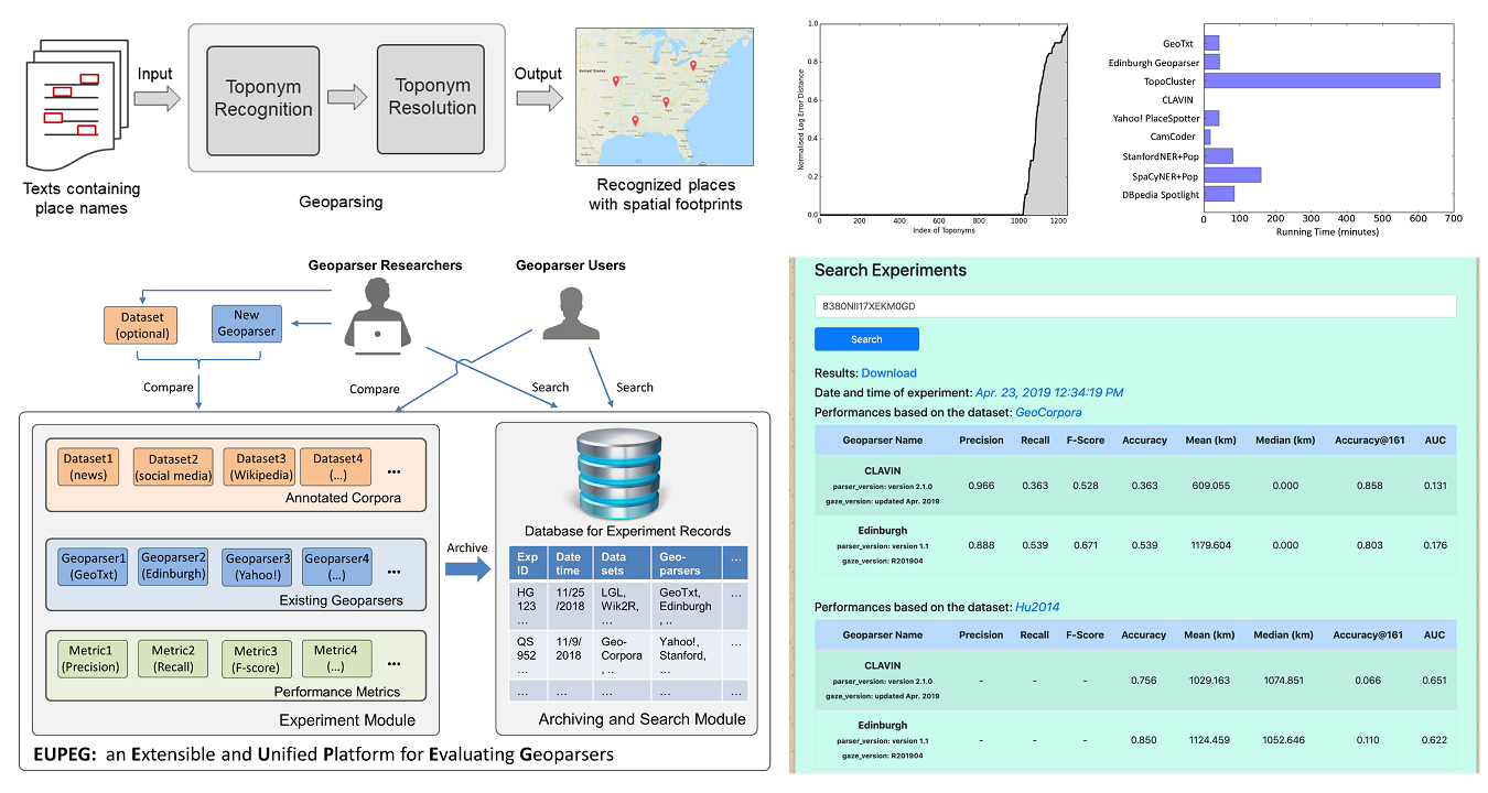 This project develops EUPEG: an Extensible and Unified Platform for Evaluating Geoparsers. EUPEG is an open source and web‐based benchmarking platform which hosts the majority of open corpora, geoparsers, and performance metrics reported in the literature. It enables direct comparison of the geoparsers hosted, and a new geoparser can be connected to EUPEG and compared with other geoparsers.
Paper: https://onlinelibrary.wiley.com/doi/10.1111/tgis.12579
Code and Data: https://github.com/geoai-lab/EUPEG
Topic Modeling and Sentiment Analysis
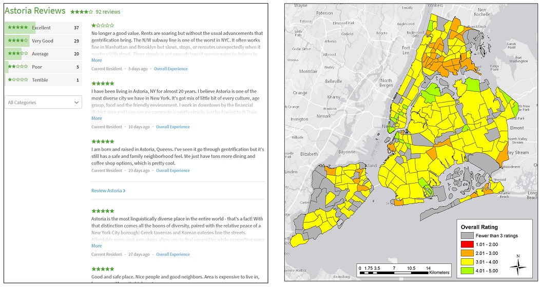 The perceptions of people toward neighborhoods reveal their satisfactions with their living environments and their perceived quality of life. In this project, we analyze online neighborhood review data to understand the perceptions of people toward neighborhoods. Specifically, we perform topic modeling to understand the semantic topics that people talk about their neighborhoods, and sentiment analysis to understand the emotions expressed by people.
Paper: https://doi.org/10.1080/24694452.2018.1535886
Code and Data: https://github.com/geoai-lab/TopicAndSentimentAnalysis
Harvesting Local Place Names from Housing Posts
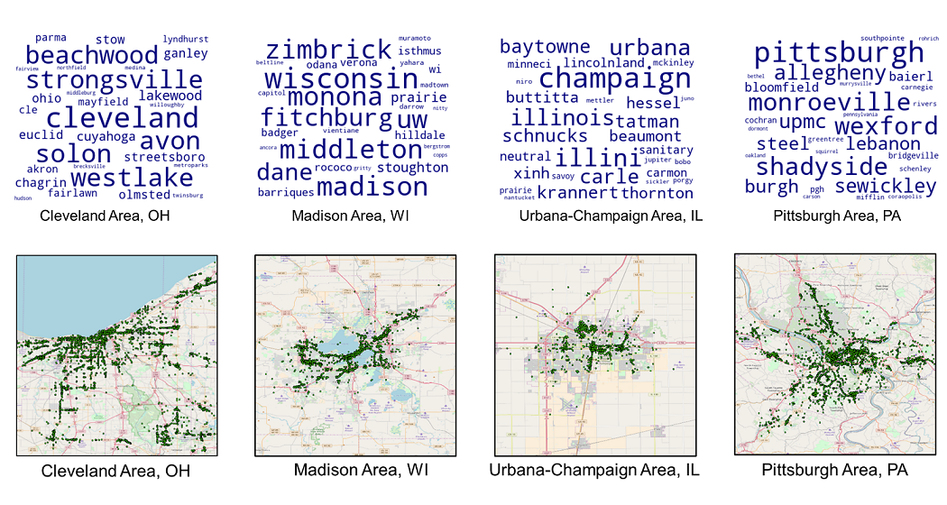
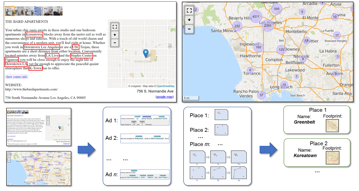 Local place names are frequently used by residents living in a geographic region. Such place names may not be recorded in existing gazetteers. In this work, we propose a computational framework for harvesting local place names from geotagged housing posts. We make use of those posts on local-oriented websites, such as Craigslist, where local place names are often mentioned. The proposed framework consists of two stages: natural language processing (NLP) and multi-scale geospatial clustering.
Paper: https://www.tandfonline.com/doi/abs/10.1080/13658816.2018.1458986
Code and Data: https://github.com/YingjieHu/LocalPlaceName
Place Names and Their Changes with Geographic Distance
 In this project, we conduct an empirical study based on 112,071 POIs in seven US metropolitan areas extracted from an open Yelp dataset. We propose to adopt term frequency and inverse document frequency in geographic contexts to identify local terms used in POI names and to analyze their usages across different POI types. Our results show an uneven usage of local terms across POI types. We also examine the decaying effect of POI name similarity with the increase of distance among POIs.
Paper: http://dx.doi.org/10.4230/LIPIcs.GISCIENCE.2018.5
Code and Data: https://github.com/YingjieHu/POI_Name
Semantic Relatedness between Cities via News Articles
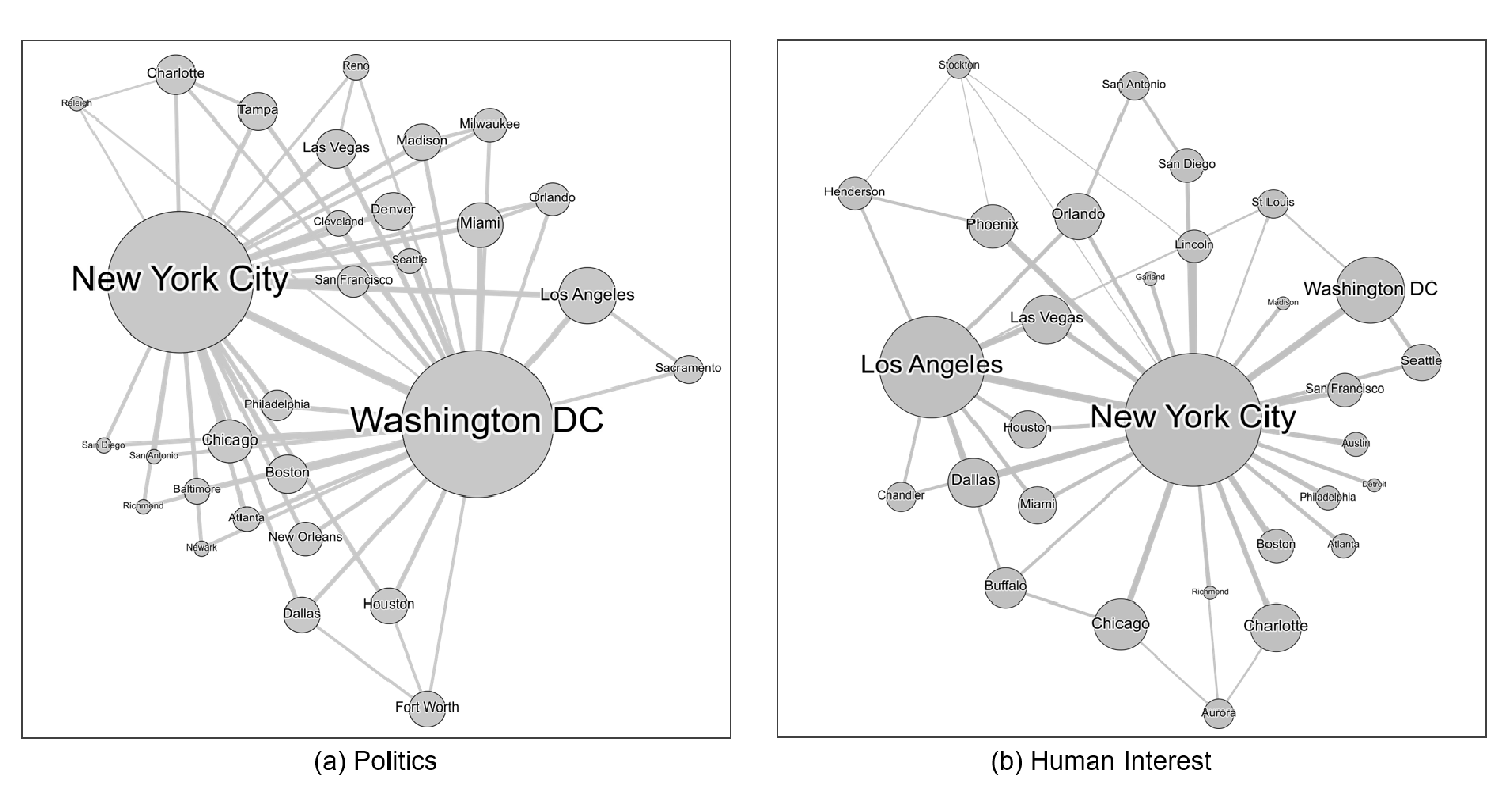 This project develops a topic modeling based workflow for extracting semantic relatedness between cities from news articles. News articles contain a rich amount of information about cities and their relations. The developed workflow makes use of city co-occurrences in news articles, and employs a topic model, LLDA, to analyze the full texts of news articles and to extract city relatedness. The extracted semantic relatedness can contribute to applications such as urban planning and GIR.
Paper: http://www.tandfonline.com/doi/abs/10.1080/13658816.2017.1367797
Code and Data: https://github.com/YingjieHu/CityRelatednessViaNews