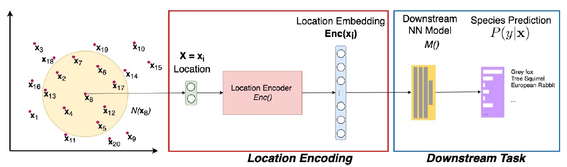
A common need for artificial intelligence models in the broader geoscience is to represent and encode various types of spatial data, such as points (e.g., points of interest), polylines (e.g., trajectories), polygons (e.g., administrative regions), graphs (e.g., transportation networks), or rasters (e.g., remote sensing images), in a hidden embedding space so that they can be readily incorporated into deep learning models. One fundamental step is to encode a single point location into an embedding space, such that this embedding is learning-friendly for downstream machine learning models such as support vector machines and neural networks. We call this process location encoding. However, there lacks a systematic review on the concept of location encoding, its potential applications, and key challenges that need to be addressed. This paper aims to fill this gap. We first provide a formal definition of location encoding, and discuss the necessity of location encoding for GeoAI research from a machine learning perspective. Next, we provide a comprehensive survey and discussion about the current landscape of location encoding research. We classify location encoding models into different categories based on their inputs and encoding methods, and compare them based on whether they are parametric, multi-scale, distance preserving, and direction aware. We demonstrate that existing location encoding models can be unified under a shared formulation framework. We also discuss the application of location encoding for different types of spatial data.
More details are available in our paper at:
Gengchen Mai, Krzysztof Janowicz, Yingjie Hu, Song Gao, Bo Yan, Rui Zhu, Ling Cai, and Ni Lao (2021): A review of location encoding for GeoAI: methods and application. International Journal of Geographical Information Science, in press. [PDF]